

Maps can open a window into the past in a way that few other things can. Whether you’re looking for wall decorations that reflect your fascination with history, or need a gift for a friend who happens to be an avid history buff, Maps are the perfect answer. These are some of the most unique and interesting maps for history lovers.
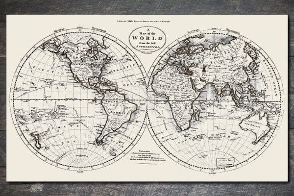
World Map 1795
Perhaps the most striking thing about this beautiful world map, first printed in 1795, is how accurate it appears. It’s a double-hemispheric representation of the earth (technically known as a Nicolosi globular projection) and despite a few inaccuracies, it offers a fascinating look at the world during the Colonial era. This 1795 World Map was first published by Mathew Carey, an Irish-born American publisher whose other notable contributions to mapping history include issuing the first general atlas of the United States.
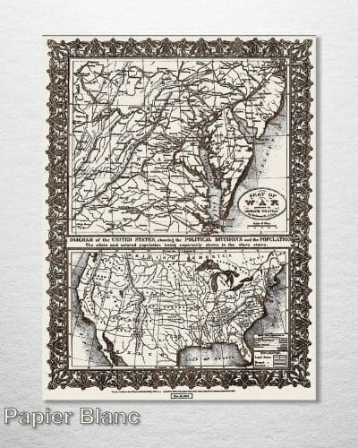
1861 US Seat of War
This Civil War-era map is really two maps in one. It’s the work of Horace Thayer, a noted 19th century publisher and lithographer, whose maps are considered some of the finest of that time period. In addition to a full United States map showing state populations and political divisions, this publication features a close-up of Washington, DC and the surrounding states, including railroad lines and other details of strategic importance.

Chicago, Illinois “Burnt District” Map
In modern times, it’s almost impossible to imagine the devastation caused by urban fires during the 19th century. The Great Chicago Fire of 1871 burned across a 3.3 square-mile swath of Downtown Chicago, destroying more than 17,000 structures and leaving at least 100,000 people homeless. Although the precise publication date of this map, which depicts Chicago’s “Burnt District” in the wake of the fire, is not known, its stated purpose was “for the benefit of the relief fund,” which likely places it in the immediate aftermath of the event.

Plan de la Ville de Paris 1805
Originally published in 1805, this striking French map shows Paris and the surrounding area as it appeared at the start of the 19th century. Students of European history might note that this map dates to just six years after the end of the French Revolution, and displays a city that looks markedly different than it would have appeared just a decade earlier. Comparing the Plan de la Ville de Paris 1805 to a present-day map of the city also offers a striking glimpse into how the city has grown in the two centuries since its publication.

Historic Map of the Southern Pacific Railroad
Railroad buffs will get a kick out of this historic railway map, which delineates the American West as it appeared in 1875. Originally developed by the Southern Pacific Railroad Company, this two-panel map shows both existing and proposed railway routes from that time, along with cities and towns, counties, drainages and landscape features. It’s a beautifully detailed piece of work that represents a crucial moment in the history of America’s westward expansion. Included on the map is the very first section of the Southern Pacific Railroad, which connected California to Utah in 1869.

Alaska 1909 Historic Map
Dating to 50 years before Alaska became a U.S. state, this Alaska 1909 Historic Map is an intriguing window into history. Gold was discovered in Alaska in 1898, kicking off a gold rush that reached its peak around 1903, but would still have been very fresh in many peoples’ minds when this map was first issued. Interestingly, Alaska wasn’t even a U.S. territory yet in 1909, but was generally referred to as the “District of Alaska,” having been purchased from Russia by the United States in 1867.

New York Subway 1918
When this map of the New York City Subway was first issued in 1918, the first underground line of the city’s train system had only been operational for about 14 years. Even so, the city was every bit the bustling metropolis then that it is today, and some of the most notable landmarks along the Subway system—Grand Central, Times Square, Penn Station—are clearly discernible on this vintage map. It’s fun to imagine this map, which was printed by the Manhattan Publishing Company, being used by commuters in 1918 as they made their way through the Big Apple.
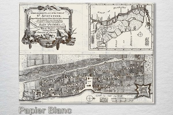
Saint Augustine, Florida 1764
founded in 1565 by Don Pedro Menendez de Aviles of Spain, the Florida city of Saint Augustine is widely considered to be the oldest city in the United States. This meticulously hand drawn map dating back to 1764 shows the city as it appeared during a pivotal point in history. The 1763 Treaty of Paris, which transferred Florida from Spanish to British rule, was just a year old, and the American revolution was still a little over a decade away. The Saint Augustine depicted on this historic map is a city in the midst of a period of great turmoil and change.

1871 Campaign Map of Texas Louisiana and Arkansas
Texas had been granted statehood in 1845, seceded from the United States along with the rest of the Confederacy in 1861, and was restored to the Union in 1870. This map of Texas, Louisiana and Arkansas was published after the war had ended, but is very much a product of the Civil War. Depicted in intricate detail are various battlefields and marches of Major General John G. Walker’s Texas Division, the only division in the Confederate army that was composed of troops from a single state throughout the entirety of the Civil War.

Valley Forge Encampment 1778
Anyone with an interest in American history can get something out of this map, which depicts the Valley Forge Encampment in 1778, during the height of the Revolutionary War. The Continental Army set up their winter camp at this strategic spot outside Philadelphia from December 1777 to June 1778. The map is drawn with incredible precision, and one can almost get lost in its fine details, like the locations of various brigades, each general’s headquarters, forts, rifle pits and lines of entrenchment.